From Common Ground to Village Green
Learn how a village green’s layout, paths and shared features reveal its present-day role, and how to turn those observations into a clear village record.
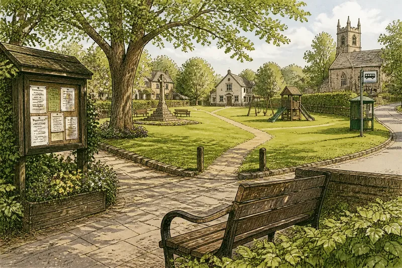
A village green’s shape and everyday uses reveal how it fits into village life now, even when its earlier story remains uncertain. From a bench beside a noticeboard to a worn path connecting two lanes, the details can show how people gather, pause and pass through shared space.
Rather than tracing old boundaries or guessing at origins, look at what the space makes possible for residents today. A short visit, a simple sketch and a few observations of how the place is arranged can help you describe its role without confusing appearance with formal status.
Start with daily use
Choose a village green or another open space that can be viewed from public ground. Notice where people can sit, play, cross or meet. A bench facing the road invites a different kind of pause than one tucked beside a quiet hedge; a noticeboard near a path may make community information easy to see.
Look for several kinds of use rather than deciding that one feature defines the whole space. A grassy area might offer room for informal play, while a paved corner provides a place to wait or talk. A memorial may invite quiet reflection, and a path through the middle may serve as a practical shortcut.
Observe without photographing or describing identifiable people unnecessarily. The useful subject is the arrangement of the space: where a path leads, which areas are open, and how features relate to one another.
Map the shared space
Make a quick sketch from a public viewpoint. Mark the main open area, visible entrances, paths, seating, signs, play equipment, trees and any obvious barriers. Add nearby landmarks such as the church, bus stop, village hall or shop so another person can understand where you stood.
For each feature, note what it appears to support. A path that links the shop to the bus stop may help people cross the green on a daily errand. A low wall beside a bench may create a sheltered sitting spot. Keep these descriptions grounded in what is visible; avoid claiming that a feature was designed for a particular purpose unless a reliable local source confirms it.
If you use a phone, a notes app or a basic map application can help you record the visit. A paper notebook works just as well. The point is to leave with a legible account, not a precise survey.
Notice welcome and access
Consider how easy the space seems to enter and use. Are there clear paths from nearby streets? Can someone approach a bench without crossing a muddy or steep patch? Are signs easy to spot, and do they explain local expectations? Record the visible details without assuming that every visitor has the same needs.
Look for contrasts within the space. A smooth route might lead to a bench, while the grass beyond it is uneven. A playground may be lively and enclosed, but the rest of the green may remain open. These observations can help a village group identify practical questions for a later discussion.
Access rules are not always apparent from the layout. If a sign limits an activity or a gate is locked, record what it says or shows and follow the posted guidance. Ask the relevant local authority or site manager about formal access questions.
What can a green support?
How can I tell if a green is used for gatherings?
Look for features that make people able to pause together, such as seating, a noticeboard or an open central area. These details suggest possible uses, but a local calendar or community group can confirm which events actually take place.
What should I note about paths?
Record where each visible path begins and ends, and whether it connects useful places such as a hall, shop or bus stop. If its public status is unclear, describe it from the viewpoint you can access rather than following it into restricted ground.
Can a green serve different age groups?
Notice whether the space includes distinct places to sit, play, walk or meet. Avoid assuming who uses each feature from its appearance alone; a village organization or site manager may be able to explain how the space is intended to serve residents.
How can I share observations constructively?
Describe the feature and the practical effect you observed, then state what remains uncertain. For example, “The bench is beside the main path, but its approach is uneven” gives a useful starting point for discussion without making claims about formal access.
Turn notes into action
Say you visit an invented village green with a notebook and find a bench beside a paved path, a noticeboard near the entrance, and a grassy route that appears to connect the village hall with a bus stop. You sketch these three features, note that the paved path reaches the bench but the grassy route looks uneven, and check the noticeboard for a contact name. Your resulting account is that the green offers a visible place to sit and read community notices, while the route between the hall and bus stop may be harder to use; you can share that observation with the listed village group and ask whether the path is maintained.
- Observation: The main entrance has a clear sign. If it names a manager or local group, then use that contact for questions; otherwise, ask the parish or town council who manages the space.
- Observation: A path reaches the seating area without an obvious barrier. If the route is clear and firm-looking, then record it as an apparent approach; otherwise, note the obstacle and ask the manager about an alternative route.
- Observation: A noticeboard displays event information. If the notices include a current organizer, then contact them to confirm activities; otherwise, describe the board only as a source of posted information.
- Observation: Play equipment occupies a separate corner. If the sign identifies age guidance or rules, then record those instructions; otherwise, avoid assigning an age group based on appearance.
- Observation: A bench faces a busy road. If the position makes conversation difficult, then note that as a possible comfort issue; otherwise, describe its location without judging its usefulness.
- Observation: A grassy route appears to connect two public places. If its status is confirmed by a sign or the site manager, then record the connection; otherwise, do not treat the visible track as a public right of way.
Keep a useful record
Write a short description that another resident can follow: where you viewed the green, which features you noticed, how the paths and seating relate, and what questions remain. Separate direct observations from interpretation. “A noticeboard stands beside the north entrance” is an observation; “the entrance is used for village events” needs confirmation.
For a clear account of a village green, name the visible features and say what they allow people to do, while leaving uncertain matters open. That small distinction makes notes more useful to a village group, a visitor or a future reader—and keeps the focus on how shared space works in everyday life.